Find the Best Aerial Surveyors Near You
- Post a job
- Receive multiple quotes
- Choose your preferred Aerial Surveyors service provider
Where do you need Aerial Surveyors?
Describe your job and our suppliers will send you quotes
Popular Aerial Surveyors Locations
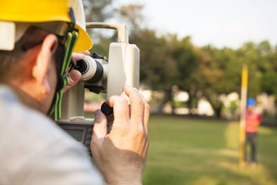
Aerial Surveyors for Hire on iseekplant
Step into the future of construction with aerial surveying, a game-changing service using cutting-edge technology that's reshaping how we gather crucial survey data for projects. Aerial Surveying uses drones to capture survey data above your construction site, as well as detailed images that help you plan, design, and monitor sites with unparalleled precision.
Aerial Surveyors Rates Guide
Curious about the cost of hiring an aerial surveyor? Our comprehensive rates guide breaks down the prices involved, giving you a clear understanding of what to expect. Aerial surveying rates can vary depending on factors such as the complexity of the project, the equipment used, and the experience of the surveyor. To help you plan your budget effectively, we've compiled a table outlining the average prices for different aerial surveying services:
| Service | Average Cost |
|---|---|
| Aerial Photography | $200 - $400 per hour |
| LiDAR Mapping | $500 - $800 per acre |
| 3D Modelling | $1000 - $2000 per project |
| Progress Monitoring | $800 - $1500 per month |
| Site Inspection | $300 - $500 per visit |
Note: All prices listed on this page are estimates, exclude GST and are in AUD. Price estimates can vary based on location, model and additional requirements.
Additional Costs to Consider in Aerial Surveying
Considering additional costs in aerial surveying is pivotal for comprehensive budget planning. Beyond the base rates, several overlooked expenses can impact the overall cost of aerial surveying projects. Understanding these can help ensure there are no surprises and facilitate smoother project execution.
| Additional Cost | Standard Rate | Description |
|---|---|---|
| Data Processing and Analysis | $500 - $2,000 per day | Cost for processing raw data into usable formats and detailed analysis. |
| Permit and Licensing Fees | $100 - $1,000 | Fees associated with obtaining necessary airspace permissions and surveying licenses. |
| Travel and Accommodation | $150 - $500 per day | Costs for crew travel and accommodation, especially for remote locations. |
| Emergency Weather Downtime | $200 - $800 per day | Unforeseen costs due to weather-related delays, requiring additional project time. |
| Equipment Transportation | $300 - $1,500 | Fees for transporting drones or other aerial survey equipment to and from the project site. |
When planning your aerial surveying project, it's crucial to consider these additional costs for a realistic budget. Use our Get a Quote tool today to connect with our suppliers for tailored quotes that cover all potential fees for your project’s needs!
Popular Brands and Models for Aerial Surveying
Choosing the right tools and brands for aerial surveying can significantly impact the accuracy and efficiency of your projects. The right equipment ensures precise data collection and analysis, crucial for making informed decisions. Equally important is selecting reputable brands known for their reliability and performance in the field.
These brands embody the pinnacle of aerial surveying technology, each bringing unique strengths to your surveying needs. When selecting equipment for your next project, consider these options for their proven track records in delivering precise and reliable data:
- Trimble: Renowned for precision and versatility, Trimble offers cutting-edge technology for comprehensive surveying solutions. Their equipment is ideal for detailed terrain mapping and analysis.
- DJI: DJI's drones are popular for aerial surveying due to their high-quality imaging capabilities and ease of use. They're perfect for capturing detailed aerial photographs and videos.
- Leica Geosystems: Leica is synonymous with high-precision surveying instruments. Their tools are designed for professionals requiring the utmost accuracy in their surveying tasks.
- Topcon: Topcon excels in integrating surveying and positioning technology, offering tools that improve productivity and precision in various surveying applications.
- SenseFly: SenseFly drones are tailored for mapping and surveying, known for their endurance and the quality of data they collect. Ideal for covering large areas efficiently.
This table compares the best of the best that each brand offers in aerial surveying:
| Brand | Popular Model | Technical Specs | Special Features | Pros | Cons |
|---|---|---|---|---|---|
| Trimble | R10 GNSS System | Multi-channel, multi-frequency GNSS, centimetre-level accuracy | Integrated RTK for real-time corrections | High accuracy even under tree canopy or near buildings | High cost, requires knowledge for optimal use |
| DJI | Phantom 4 RTK | 20 MP camera, RTK GNSS module, 30-minute flight time | 1cm+1ppm RTK vertical & horizontal accuracy | Highly portable, excellent for detailed mapping | Limited flight time, affected by weather |
| Leica Geosystems | BLK2FLY | Autonomous flying laser scanner, 360° visual coverage | Easy-to-use interface, automatic flight planning | Fast, comprehensive 3D mapping of complex environments | Premium cost, training required for best results |
| Topcon | Falcon 8+ | Advanced V-shaped design for stable flight, high payload capacity | Precision in image acquisition, resistant to magnetic fields | Suitable for inspection and monitoring in harsh conditions | Specialist operation, higher learning curve |
| SenseFly | eBee X | Up to 90-minute flight time, multi-payload options | Coverage of up to 500 ha (1,235 ac) per flight | Versatile use across different surveying applications | Requires runway for takeoff and landing |
Applications of Aerial Surveying in the Construction Industry
Aerial surveying is a game-changer for jobsites with large geographic expanses of land that are hard to reach by road. By utilising drones, aircraft, or satellites, construction professionals can access a wealth of data that can be used in both the design and construction phases of a project. Let’s explore the different applications of aerial surveying.
- Site Planning and Design: Aerial surveying provides detailed topographic maps and 3D models of project sites, aiding in site planning and design. This information helps engineers make informed decisions about structure placement, road design, and drainage systems.
- Volume Calculations: Aerial surveying can be used to calculate stockpile volumes of materials such as earth, gravel, or sand. By regularly surveying stockpiles, construction companies can manage inventory more effectively and reduce material waste.
- Progress Monitoring: Aerial surveying allows for real-time monitoring of construction progress, enabling project managers to track milestones and identify any issues that may arise. This visibility helps to keep projects on schedule and within budget.
- Environmental Impact Assessment: Aerial surveying can be used to assess the environmental impact of construction projects, helping to identify potential risks and mitigate them before they become problems. This proactive approach can lead to more sustainable construction practices.
- Safety Inspections: Aerial surveying allows for the inspection of hard-to-reach or hazardous areas, reducing the need for workers to access these areas manually. This improves safety on construction sites and reduces the risk of accidents.
- Infrastructure Monitoring: Aerial surveying can be used to monitor the condition of infrastructure such as bridges, roads, and buildings. By regularly surveying infrastructure, construction companies can identify maintenance needs early and prevent costly repairs.
- Utility Mapping: Aerial surveying can be used to map underground utilities such as pipelines and cables. This information is crucial for avoiding conflicts during construction and ensuring that utilities are not damaged during excavation.
Experience Expert Aerial Surveying with iseekplant today!
With iseekplant, you have access to our extensive network of trusted aerial surveying service providers, ensuring that your project is handled expertly by professionals. Contact iseekplant today and experience the difference in Aerial Surveyors services! Shoot us an email at projects@iseekplant.com.au for any queries, or ring us at 1300 691 912. To get rolling, just tap on 'Get a Quote'!
Become a supplier
How It Works
Aerial Surveying FAQs
Here are some tips and frequently asked questions on how to find the right aerial surveyor for your job.
What do we have to offer?
Want to Know More?
Types of Surveyors & Costs 2022- Find a surveyor | iseekplant
Have you ever wondered how large structures or long distances are measur...